Best Hikes in Haute-Savoie
With an area of 4388 km2, Haute-Savoie (74) is a hiking area par excellence with its many massifs at both medium and high altitude. Haute-Savoie includes the following main massifs:
In this regard, you will find below a selection of hiking routes that I have been able to do in Haute-Savoie. Each hiking itinerary is carefully documented with a description, a route and photos. Feel free to send your comments or remarks by email or at the bottom of the corresponding articles.
21 June 2009 | by Pierre-Alexandre
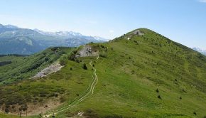
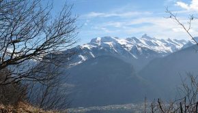
Visible from Sallanches, Croisse Baulet is a stroll of choice that will provide the hiker with one of the most beautiful views of Haute-Savoie as one can contemplate the Mont Blanc Massif, the Aravis Range, and the Fiz Massif
4 January 2009 | by Pierre-Alexandre
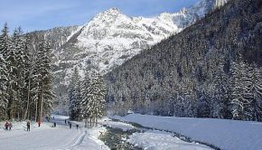
The Bois du Bouchet is a magnificent stroll within the reach of all, in a sumptuous setting, a few minutes from the center of Chamonix. It gives the right to see the highest peaks of the valley by strolling on a marked circuit without any difficulty
1 October 2008 | by Pierre-Alexandre
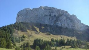
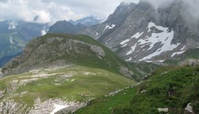
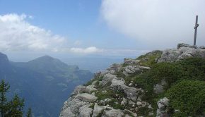
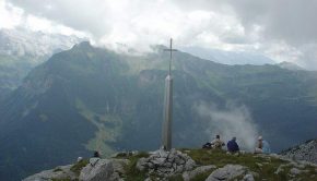
Overlooking the Bornes Massif, Roche Parnal presents itself as a large rocky boulder between Montagne de Sous-Dine and the Trampes.
Once at the top of Roche Parnal, you will discover a magnificent panorama
14 September 2008 | by Pierre-Alexandre
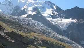
The Nid d’Aigle is the terminus of the famous Mont Blanc train, the arrival point of a very large number of tourists of all nationalities and departure of the route to Mont Blanc.
The route passes through the pastures of the Are and follows
6 August 2008 | by Pierre-Alexandre
Let’s go to Morzine for a hike that takes part of the “GR 5 Tour des Dents Blanches” to get to the Tête de Bostan.
The route starts from the Pont de Chardonnière, crosses the Terres Maudites
26 July 2008 | by Pierre-Alexandre
Tête Pelouse is the object of a superb hike that will make you discover the Aravis Range and the beautiful Valley of Confins. Not so far from the Lac and Pointe de Tardevant, the itinerary reaches a rocky summit not very frequented that offers an unforgettable point of view
17 May 2008 | by Pierre-Alexandre
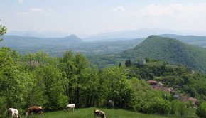
The Vuache is located in the west of Haute-Savoie. It is part of the Jura Massif from which it is separated by the Cluse of the Rhône. The Vuache is a narrow secondary range of 14 km in length and 1.5 to 3 km in width, Northwest-Southeast oriented
27 April 2008 | by Pierre-Alexandre
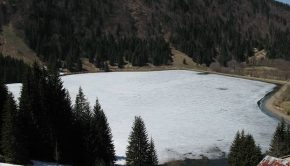
Lac des Plagnes can be the object of a beautiful family walk in the Valley of Abondance. Very popular with fishermen in summer, its banks are accessible by a small path that makes a loop and allows admiring the surrounding landscape
5 March 2008 | by Pierre-Alexandre
With Montagne de Chevran, Mont Orchez constitutes a superb belvedere on the Valley of the Arve facing the Môle and the Bargy Massif.
Without any difficulty, the path gets through a beautiful forest by a sometimes very steep path. In wet weather, the descent can be very slippery
16 August 2007 | by Pierre-Alexandre
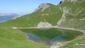
Located at the southern end of the Aravis Range, Mont Charvin dominates the town of Ugine. The Lac du Mont Charvin, nestled in a beautiful basin at the foot of the eponymous summit is the goal of this hike.
There is no real difficulty: a very short and steep passage under the Col des Porthets and a brief
3 August 2007 | by Pierre-Alexandre
The Tour des Rochers de Leschaux is part of the excursions demanding little effort, but which still require a good physical condition considering the length of the itinerary, as well as a secure foot to get through several steep passages with high declivity (but no exposed passages).
The Rochers de Leschaux
29 July 2007 | by Pierre-Alexandre
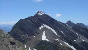
The panorama discovered at the top of the Petit Bargy will enchant hikers wishing to contemplate the greater part of the Aravis Range.
Made of limestone, the imposing Bargy Massif is ideally located for a discovery of the Aravis. In addition, many ibexes have settled on the