Best Hikes in Haute-Savoie
With an area of 4388 km2, Haute-Savoie (74) is a hiking area par excellence with its many massifs at both medium and high altitude. Haute-Savoie includes the following main massifs:
In this regard, you will find below a selection of hiking routes that I have been able to do in Haute-Savoie. Each hiking itinerary is carefully documented with a description, a route and photos. Feel free to send your comments or remarks by email or at the bottom of the corresponding articles.
3 November 2005 | by Pierre-Alexandre
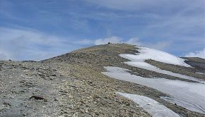
Little visible from the valley, Pointe d’Ireuse presents itself rather under the appearance of a vast dome than under the aspect of a peak. The itinerary describes a loop passing through the Chalets de Nifflon d’en Bas, then the picturesque chapel of Nifflon d’en Haut, with a return to the
11 October 2005 | by Pierre-Alexandre
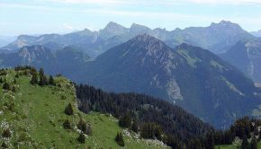
I propose here a small walk above Cluses. The Montagne de Chevran offers a spectacular view over the Valley of the Arve, Pointe d’Areu, the Môle, Pointe d’Andey, and many other summits
22 September 2005 | by Pierre-Alexandre
The itinerary that I propose here is more a half day trip than a real hike as the elevation gain and distance are negligible. The magnificent mountain pastures and the very close summits will make this itinerary an unforgettable memory for young and old alike
20 August 2005 | by Pierre-Alexandre
I propose here two itineraries in one: Pointe Percée and the Col des Verts.
The ascent of Pointe Percée is definitely not made for families.
The last third of the route after the ascent of a fairly steep scree requires the use of the hands to rise in faults and chimneys on slippery rocks
7 August 2005 | by Pierre-Alexandre
The ascent of Mont Buet can be seen as the culmination of a hiking season of varying levels of difficulty, as the objective is very high, the elevation gain very important, and the route very long.
Several technical difficulties are encountered: a trail with cairns only after the refuge, a passage of large
23 July 2005 | by Pierre-Alexandre
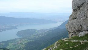
La Tournette is a superb spot to contemplate all the summits above Lake Annecy as well as the Aravis Range and the Mont Blanc Massif, sometimes hidden by the clouds when it's hot. This route is somewhat technical in its final part, as many passages are equipped with cables and
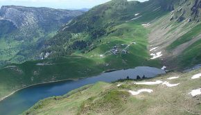
18 July 2005 | by Pierre-Alexandre
The Aravis Range is made up of a succession of combes delimited by calcareous peaks. The combe of Tardevant is situated in middle and is the only one to have a lake, which makes it a perfect hiking destination.
The itinerary runs along the slopes of the Grand Crêt
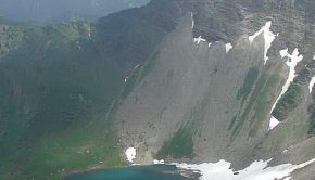
15 July 2005 | by Pierre-Alexandre
Pic du Jallouvre remains a very beautiful excursion reserved for the experienced walkers. If the beginning of the trail is a charming bucolic walk in the alpine pastures of Cenise, what follows next is quite different: very quickly, the path passes near a vast scree
12 July 2005 | by Pierre-Alexandre
Pointe de Chésery constitutes a very beautiful itinerary that dominates the village of Lindarets in the heart of the Portes du Soleil between Châtel, Morzine, and Avoriaz.
The course presents no particular difficulty, except the last part of the ascent that is a bit steep
20 June 2005 | by Pierre-Alexandre
The itinerary presented here describes a loop which allows discovering the whole site of Tavaneuse. All the beauties that one can meet during a hike are part of the scenery: high peaks, a lake, waterfalls, exposed paths, alpine pastures, late névés, and very abundant flora on the whole course.
This hike
13 June 2005 | by Pierre-Alexandre
The itinerary that I propose describes a loop that starts from the car park of the Allamands, leads to the Refuge du Col de la Golèse, climbs a little more and goes down to the Refuge de Bostan nestled at the foot of the impressive walls of the Aouille du Criou.
Note the possibility of climbing the Tête de
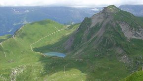
6 June 2005 | by Pierre-Alexandre
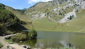
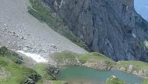
The Lac de Lessy is nestled in a valley at the foot of the Jallouvre, the Buclon, and Aiguille Verte. The route proposed from the Chinaillon is intended for good walkers; It takes a route that goes through Aiguille Verte before going down to the Lac de Lessy. In the first part of the trail, signs inform