Col and Lac d’Anterne
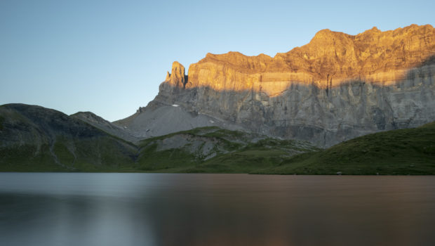
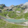
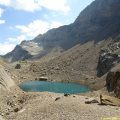
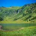
Located in the heart of the Sixt-Passy Nature Reserve, the Lac and Col d’Anterne remain a must in Haute-Savoie. Of glacial origin, Lac d’Anterne is a water reservoir of about 760,000 m3 at the foot of the majestic Rochers des Fiz. It is home to trout and Arctic char and its meadows provide a refuge for marmots and ibex. The panorama served from the shores of Lac d’Anterne is one of the most impressive in the region and naturally invites introspection. Further on, the Col d’Anterne offers an equally splendid view of the Mont-Blanc Massif and Lac de Pormenaz underneath.
The itinerary I propose starts from the Lignon car park and goes first to the Cascades de la Pleureuse and Sauffraz. Then, the tour continues towards the Collet d’Anterne and the Refuge d’Anterne Alfred Wills before reaching Lac d’Anterne after a rather challenging ascent of the eponymous mountain. Then, the course ends at the Col d’Anterne after a final climb. The hike is classified in the “Hard” category because of the length of the route (17.4 km round trip) and some passages requiring significant effort.
In order to appreciate the beauty of the landscapes discovered in the nature reserve, I recommend camping at Lac d’Anterne and climbing the Col the next morning. On a clear day at sunrise, Rochers des Fiz adorn itself with a beautiful orange dress. If you wish to camp, remember that it is only allowed to pitch your tent between 7pm and 9am in the nature reserve.
Important note: remember to come early in the morning (before 7:30 am), because the Lignon car park is very quickly saturated and it becomes impossible to park.
- Difficulty: Hard
- Altitude: 2,257 m at the Col d’Anterne
- Ascent: 3 hours 30 min to get to the Lac d’Anterne + 45 min to reach the Col d’Anterne
- Descent: 3 hours 00 min
- Elevation Gain: 1,190 meters
- Round-trip: 17.4 km
- Map: IGN 3530 ET
- Restrictions : Dogs (even on a leash) and gathering prohibited. Bivouac allowed between 7 p.m. and 9 a.m.
Getting There
Like the hike to the Chalets de Sales, the departure is from the Lignon car park (1180 m). Once you reach Sixt-Fer-À-Cheval (6 km after Samoëns), turn right on the bridge in the centre of the village towards the Cascade du Rouget. Pass the waterfall and continue along the road to the terminus (chalet-restaurant).
GPS Coordinates (WGS 84) of the Starting Point: 46.020976, 6.768192
Ascent
From the Lignon car park, take the footpath behind the chalet restaurant. It sinks into the forest and climbs slowly at first, then more frankly afterwards. Yellow arrows and red and white stripes indicating the GR 5 mark the route. A little further on, the terrain changes somewhat and evolves on rocks eroded in places. Later on, you arrive at the Cascade de la Pleureuse and de la Sauffraz. The path after that rises steeply to get to the intersection of the Cascades de la Pleureuse and Sauffraz; turn left to follow the direction of “Lac d’Anterne 2 h 40” as mentioned by the sign.
The pathway is now narrower and the progression more regular. Further on, you pass a pile of blocks before going down slightly to continue on a short flat section. The route climbs under the imposing Pointe de Sales by a rather bucolic route alternating between steep and moderate passages. Shortly afterwards, you will discover the peaks of Giffre such as Mont Buet or the Cathédrale. Finally, you reach the Collet d’Anterne, which naturally invites you to take a well-deserved break.
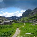
Continue on the beautiful plateau towards the Refuge d’Anterne Alfred Wills. The track loses altitude and then flattens out to advance through a superb maze of rocks and vegetation. The trail subsequently traverses a bridge over the Ruisseau d’Anterne. Later, you finally get to the Refuge d’Anterne Alfred Wills, which offers a spectacular view of the Rochers des Fiz. Many possibilities to eat are available at the refuge. It is also worth noting the presence of a fountain to fill the water bottles. From there, follow the direction of “Lac d’Anterne 1 h 05” as indicated by the sign. You then cross a new bridge over the river to climb the Montagne d’Anterne.
The climb is abrupt and requires a lot of effort. You then win a flat section and shortly after a descent leading to the magnificent Lac d’Anterne. From the lake, continue in the direction of the Col on a path well marked by red and white markers painted on the rocks. After a relatively steep first ascent, a smooth section leads the walker to the foot of the Col before a final ascent to finally reach the cross symbolising the Col.
Descent
The descent is made by the same route. To add a little variety to the course, I recommend walking on the west shore of the lake. This will reveal where the lake’s surplus goes.
Photos of the Col and the Lac d’Anterne
")
")
")
")
")
")
")
")
")
")
")
")
")
")
")
")
")
")
")
")
")
")
")
")
")
")
")
")
")
")
")
")
")
")
")
")
")
")
")
")
")
")
")
")
")
")
")
")
Route
Download the route (KML) Download the route (GPX)
This post is also available in Français
About the Author
Pierre-Alexandre 33 ans, fondateur et webmaster de Randos-MontBlanc. Suivez-moi sur @pierrealexphotography


Hey super cool hike! and amazing pictures!
I was wondering whether it was allowed to park your car at that spot for multiple days? and what does this cost?
Did you find a website about the parking maybe?
Anyways, thanks for the great article,
kind regards,
Valentijn Bijman
Hi and thank you for your kind comment 🙂
Yes, it’s allowed to parking your car at Parking du Lignon for several days since no signs are prohibiting such practice. Parking is totally free 😉
FYI, here’s a Google Street Map image of the parking: https://goo.gl/maps/jA8a2CR7EbFmD2hy8
I recommend that you park either very early in the morning or after 5 pm because it gets super full on the weekend.
Thanks you so much! That is great