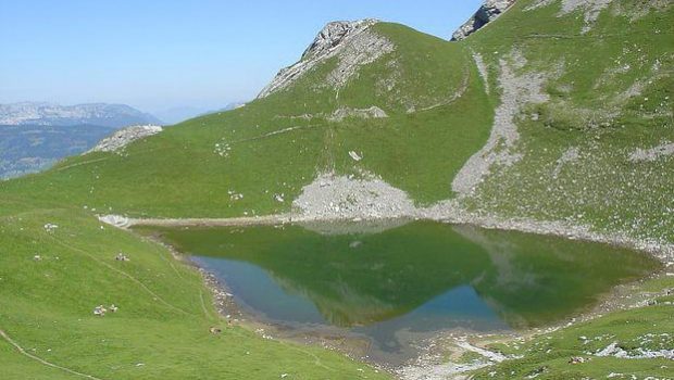
Lac du Mont Charvin
Located at the southern end of the Aravis Range, Mont Charvin dominates the town of Ugine. The Lac du Mont Charvin, nestled in a beautiful basin at the foot of the eponymous ridge is the goal of this hike.
There is no real difficulty: a very short and steep passage under the Col des Porthets and a short climb in a rather steep lapiaz arriving at the lake are the only places that can be delicate in wet weather.
For those who wish to admire the lake from a little higher outlook, a path goes right to the small plateau after the lapiaz towards a small summit (La Goenne) that overlooks the lake.
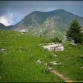
The route passes through very open alpine pastures (no shade whatsoever). Plan a departure early in the morning so as not to suffer from the heat, which would make the difficulty more important.
- Difficulty: Intermediate
- Altitude: 2,011 m
- Ascent: 2 hours 15 min
- Descent: 1 hour 30 min
- Elevation Gain: 800 meters
- Round-trip: 9.5 km
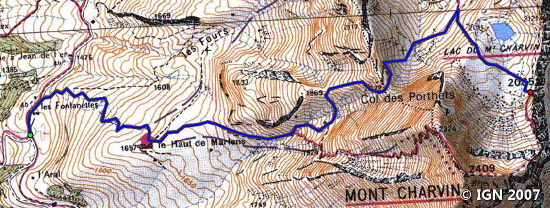
- Map: <b>IGN 3431 OT</b>
Getting There
Reach Thônes, then take the direction of Serraval via the D12 road. At the entrance of Serraval, turn left on the road towards the Bouchet by the D162 road. Pass the Bouchet, then, after a switchback, turn left towards Savataz. After the village, continue the way to a large car park.
GPS Coordinates (WGS 84) of the Starting Point : 45.798013, 6.387466
Ascent
Get to the refreshment bar of the Fontanettes by the road; Leave on the left the road going to “Le Freu” and take the path on the right that goes towards the Haut de Marlens.
After a few switchbacks, the chalets are in sight. Gain them and continue towards the Combe du Mont Charvin.
The path is steeper as you climb into the valley. At a small plateau, you arrive at a bifurcation: turn left towards the Lac du Mont Charvin.
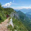
The footpath branches off to the left towards a clearly visible peak that must be reached and follows in the direction of the Col des Porthets. At the top of the ridge, a short passage bypasses a rocky peak; Be careful in wet weather as this place may be delicate.
Arriving at the Col des Porthets, go down towards the scree that is crossed by turning on the right. The pathway goes then to the bottom of a short but steep passage in the lapiaz leading to the Lac du Mont Charvin
I advise continuing until the Pas de l’Ours fifteen minutes from here as a magnificent panorama on the Mont Blanc Massif is offered to the hiker.
Note the possibility of winning Mont Charvin by the ridge on the right. I don’t recommend this path to people having a fear of heights as it’s very exposed and quite dangerous. If you decide to climb Mont Charvin from Pas de l’Ours, you’ll have to descend on the other side that directly reaches Haut de Marlens.
Descent
Take the same road as described above.
Photos of the Lac du Mont Charvin


Route
Download the route (KML) Download the route (GPX)
This post is also available in Français
About the Author
Pierre-Alexandre 33 ans, fondateur et webmaster de Randos-MontBlanc. Suivez-moi sur @pierrealexphotography


