Mont Buet
The ascent of Mont Buet is totally out of the context of a family hike. This outing can be seen as the culmination of a season of hiking of varying degrees of difficulty. The objective is very high, the difference in altitude very significant, and the route very long.
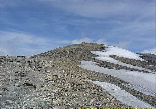
There were a number of technical difficulties: the path after the refuge was marked only by cairns, the passage of large boulders is perilous, and there are snowdrifts and patches of hard snow on the summit for much of the year. The final ascent after the 2800m mark also requires a violent effort to reach this lunar-like dome where the feeling of euphoria is total.
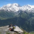
The panorama from the top of Mont Buet is breathtaking and will make you forget all your efforts. As the route is long and the altitude high, you should take the usual precautions before each hike: check the weather forecast, carry a map and bring warm clothing.
In early summer (late June to mid-July), crampons are useful for the névés and hard snow patches on the ridge.
- Difficulty: Very Hard
- Altitude: 3,096 m
- Ascent: 1 hour 45 min to get to the refuge + 2 hours 50 min to get to Mont Buet
- Descent: 3 hours 30 min
- Elevation Gain: 1,780 meters
- Round-trip: 17.7 km
- Map: IGN 3630 OT
- Restrictions : Dogs (even on a leash) and gathering prohibited. Bivouac allowed between 7 p.m. and 9 a.m.
Getting There
After Chamonix, head towards Argentière and cross the Col des Montets. After 2 km, park on the right in the car park at Le Buet station.
GPS Coordinates (WGS 84) of the Starting Point : 46.018687, 6.919560
Ascent
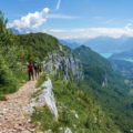
From the car park, take the path on the other side of the road towards the Pierre à Bérard refuge. Don’t be frightened when you see the signs indicating a six-hour walk to Mont Buet, as the time is really exaggerated 😉 Go through the Poya chalets towards the woods and, on a path to the right, climb towards the Chalet de la Cascade à Bérard.
Leave the Tré les Eaux path on the right and continue along the river. After crossing two footbridges, the path becomes steeper. After a few hairpin bends, the path leaves the forest. To the right, by the foothills of Le Buet, and to the left by the Aiguilles rouges, the path splits in two at a fork: take the path on the left, as it is easier than the one on the right.
You then come to the Refuge de la Pierre à Bérard. Turn right to take the path that weaves its way through a damp gully that rises quickly. You then cross an area of large granite boulders marked by white stakes. Further on, leave the Col de Salenton on the left and continue until you reach a combe that is almost always snow-covered and where caution is advised. The summit of Mont Buet is now clearly visible on the right.
The effort is now greater to reach a panoramic plateau with cairns overlooking the Diosaz valley. After a well-earned break, turn right onto the path that leads to a belay (Pictet shelter) on the Mortine ridge. It’s a tough climb and the pace is slower as you climb the very short, very steep switchbacks to the ridge. After passing the Pictet shelter, the path becomes less steep. You finally reach the large cairn marking the summit of Mont Buet, which is often covered by large patches of snow in early summer.
Descent
Retrace your steps and take the same path you took on the way up. A short diversions takes you to the Col de Salenton, marked by a clearly visible cairn on the right. This pass offers another view of the Aiguilles Rouges. Note that the Col d’Anterne also provides a link to Lac et Col d’Anterne.
Photos of Mont Buet


Route
Download the route (KML) Download the route (GPX)
This post is also available in Français
About the Author
Pierre-Alexandre 33 ans, fondateur et webmaster de Randos-MontBlanc. Suivez-moi sur @pierrealexphotography


Hi Pierre. I’m planning to summit Mount Buet mid June. Should I expect snow at any point in the trail at that time of the year? I’m planning on get to the summit in one day. Any advice? thank you very much.
Hi Fede,
If you want to attempt the ascent mid-June, you should expect snow on the last part. The first part of the ascent, all the way to the Refuge de la Pierre à Bérard, should be snow-free. You’ll likely encounter névés and snow patches a bit before Col de Salenton. I highly recommend bringing a pair of raquettes or crampons.
Leave the starting point at 7:30 am at the latest to reach the top before noon 😉
Hello.. planning to do the trek mid October.. any advice, equipment or route recommendations would be much appreciated.
Chappy
Hi,
Normally, you shouldn’t expect any snow mid-October as snow usually appears mid-November, even at such an altitude. You can follow the route as described in my description. I would suggest though that you take warm clothes with you as it can get cold at this time of the year, especially when the wind blows.
Hi!
How about ascending Mont Buet in late April? Is it safe? Is it even possible? I suppose there is still lot of snow in April.
Thank you!
Hi,
Yes, it’s indeed possible to climb Mont Buet in late April. Nonetheless, there’s still a lot of snow on the massif (about 2 meters), so you’ll need either snowshoes or skis. Personally, I prefer the ski touring option because it makes the descent much more pleasant.
Thanks for the answer.
One more question – is there any place/trail at Samoens where I could ascend and see Mont Blanc summit?
Asking because I’ll be at Samoens in late April and as I love hiking I just need to take a chance and do some hike. Even if it’s not hiking season. 🙂
You can indeed attempt to ascend via Samoëns. The starting point is located in Salvagny, south of Sixt-Fer-à-Cheval. From there, take the path that goes to “Le Grenairon : Chalet Hôtel du Buet”, then continue to reach la Cathédrale, la Crête de la Montagne des Eves, and finally the Buet.
You can check the track out here: http://tracedetrail.fr/fr/trace/trace/40878
It’s 28 km round-trip for 2290 meters of cumulative gain. It’s much harder than the path I describe in my article.
Hi – two questions. First, is it possible to ascend Mt Buet from the east (Samoens)? Second, how difficult is the terrain? For reference I am a skyrunner, done Mont Blanc 80Km 5 times. Thanks for any help, Dominic
Hi,
Yes, it’s possible to ascend Mont Buet from Samoëns (Salvagny hamlet). Here’s the map with the path to follow: http://tracedetrail.fr/fr/trace/trace/40878
I’ve never climbed Mont Buet from this side, but according to the map and what I could hear from some of my fellow visitors, it’s much steeper than the path I’ve described here since it’s 28 km long round-trip and has a 2200-meter elevation gain. Unfortunately, I don’t know exactly how the terrain looks, but it shouldn’t be much different from what you could experience during the Mont Blanc 80 Km race.
Thank you for this, it is very helpful. I might try it in two halfs before the single cross.