Hikes whose elevation gain ranges from 850 to 1500 meters.
Browsing the "Gain = 850-1500 meters" Tag
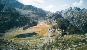
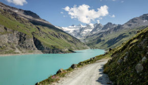
Lago del Rutor via Rutor Waterfalls and Lac du Glacier
21 September 2020 | by Pierre-Alexandre
Nestled in the Valle d'Aosta, Lago del Rutor is a little jewel of the Mont Blanc Massif. Indeed, it remains the object of a magnificent hike
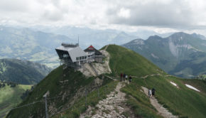
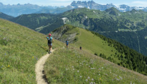
The Moléson
22 June 2020 | by Pierre-Alexandre
The Moléson is an emblematic mountain of the Fribourg Pre-Alps offering a prime hiking destination. Culminating at an altitude of 2002 m, the Moléson is very recognizable by its shape
Augstmatthorn via Harderkulm
4 October 2019 | by Pierre-Alexandre
Le Augstmatthorn est une cime mythique des alpes bernoises. Du haut de ses 2136 m d’altitude, le Augstmatthorn domine le Lac de Brienz en contrebas et offre un des plus beaux panoramas des Alpes
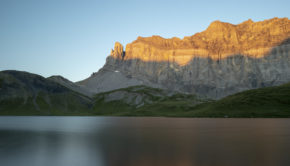
Col and Lac d’Anterne
19 August 2019 | by Pierre-Alexandre
Located in the heart of the Sixt-Passy Nature Reserve, the Lac and Col d'Anterne remain a must in Haute-Savoie. Of glacial origin, Lac d'Anterne is a water reservoir of about 760,000 m3 at the foot of the majestic Rochers des Fiz
Mont de Grange
2 August 2019 | by Pierre-Alexandre
Mont de Grange is one of the iconic peaks of the Chablais Massif. At an altitude of 2432 m (which is identical to that of the Cornettes de Bise), Mont de Grange dominates the Val d'Abondance in all its splendour. The panorama offered to the hiker is undoubtedly one of the most beautiful in
Pointe d’Areu (Pointe des Arbennes)
22 July 2019 | by Pierre-Alexandre
Pointe d'Areu is a mountain overlooking the Arve valley at the end of the Aravis massif. Due to an omission on the IGN map, the Pointe d'Areu is often confused with the Pointe des Arbennes (also called Pointe d'Arbenne or Pointe d'Areu de Romme)
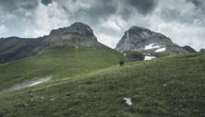
Col du Pigne via Cabane de Moiry
31 July 2018 | by Pierre-Alexandre
Located in the Val d’Anniviers in the heart of the Valais, under the imposing Pigne de la Lé, the Col du Pigne is the subject of a hike that will surely remain in the memory of the walker in search of breathtaking landscapes. The route starts at the Moiry Dam at 2250 m above the village of Grimentz
The Salève (via Etrembières)
13 October 2017 | by Pierre-Alexandre
The Salève is an emblematic summit of Haute-Savoie and the Geneva Basin, offering the walker a panorama of choice on the vast majority of the peaks of the region, as well as on Lake Annecy and Lake Geneva. A quick look at the map shows that several hiking routes are possible in order to climb
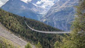
Charles Kuonen Suspension Bridge
20 August 2017 | by Pierre-Alexandre
The Charles Kuonen Suspension Bridge (or Charles Kuonen Hängebrücke in German) is located in Randa in the Valais Alps and is a must-see on the Europaweg trail from Grächen to Zermatt. The bridge is 494 meters long and weighs 58 tons and is the longest pedestrian suspension bridge in the
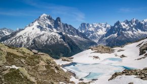
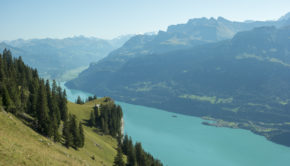
Lac Blanc (via the Col des Montets or Tré-le-Champ)
11 June 2017 | by Pierre-Alexandre
Must-see in the Chamonix Valley, Lac Blanc exhibits an unforgettable panorama on the Mont Blanc Massif. The itinerary described here offers a much more bucolic setting than the alternative route by the Flégère
Crêt de la Neige and Reculet
9 April 2017 | by Pierre-Alexandre
Crêt de la Neige and Reculet constitute a superb balcony on Lake Geneva and the peaks of the Alps. The itinerary that I propose describes a loop that begins in the forest to reach the foothills of the massif before ascending further to win the Crêt de la Neige, the highest summit of the Jura
La Jonction (Chamonix)
23 September 2016 | by Pierre-Alexandre
La Jonction (The Junction) is one of the classics of the Mont Blanc Massif and the Chamonix Valley. Joining the Bossons and Taconnaz Glaciers, La Jonction offers a staggering view of the Aiguille du Midi, the Dôme du Gôuter as well as the Aiguilles Rouges
Randos les plus populaires


