Lago del Rutor via Rutor Waterfalls and Lac du Glacier
Nestled in the Valle d’Aosta, Lago del Rutor is a little jewel of the Mont Blanc Massif. Indeed, it remains the object of a magnificent hike that allows you to discover an incredible diversity of landscapes.
The route I propose here is in three parts. It starts from the car park of La Joux and then joins the three impressive Rutor Waterfalls, which originate in the lake of the same name. Then it reaches the Lac du Glacier in a second stage and finally the Refuge Albert Deffeyes and the Lago del Rutor. Although the profile of the route is regular, I have classified the route to the Lago del Rutor as “hard” because of its length.
- Difficulty : Easy for Rutor Waterfalls
Intermediate for Lac du Glacier
Hard for Lago del Rutor- Altitude : 2,494 m at Rifugio Deffeyes
- Ascent : 1 hour 20 min for Rutor Waterfalls / 2 h 10 for Lac du Glacier / 3 h 00 for Lago del Rutor
- Descent : 2 hours 30 min from Lago del Rutor
- Elevation Gain : 530 m for Rutor Waterfalls / 705 m for Lac du Glacier / 940 m for Lago del Rutor
- Round-trip : 6.5 km for Rutor Waterfalls / 9.0 km for Lac du Glacier / 13.70 for Lago del Rutor
- Map : Carte IGC 107
Getting There
Go to the parking lot in La Joux, which is small hamlet 3 km south of La Thuile. This car park is normally reserved for the bar. If you have a drink, you can park the car for the day.
GPS Coordinates (WGS 84) of the Starting Point : 45.6891676, 6.9609746
Ascent to Rutor Waterfalls (1)
In front of the bar, follow the path indicated by the sign “IIIa Cascata, 1 h 20 – Number 3”. The well-traced path runs along the alpine pastures and follows the torrent up to a wooden bridge that you have to cross. The footpath, which is always well marked, then rises more steeply to the first waterfall, which can be reached in twenty minutes.
Continue in the direction of the second waterfall following the signs for “IIIa Cascata – Number 3”. The trail then crosses a beautiful stone bridge. Once you get to the Chalet Parcet, continue along the track until you arrive at a wooden bridge which you will leave on the right. Continue following the signs “IIa Cascata” and “IIIa Cascata”. The pathway then becomes steeper and the stones sometimes slippery. After about 1 hour and 15 minutes of effort, you reach the second waterfall.
Continue on to the third waterfall, which is five minutes away. This cascade is overhung by a footbridge which gives the right to admire the waterfall on all its length. Although without risk, this perfectly safe metal footbridge can pose a problem for people who are afraid of heights. Indeed, this enormous waterfall generates a lot of spray and wind, which can be a little intimidating.
Ascent to Lac du Glacier (2)
Retrace your steps to leave the Lakes of Bellecombe on your right and take the direction “Refuge Deffeyes, 1 h 20—Number 3” as shown on the sign.
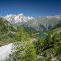
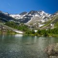
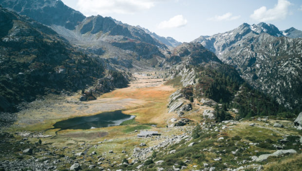
The trail, which is always very stony, becomes steeper and more open. Follow the direction of the refuge. After a short but abrupt climb, you reach a small pass overlooking the mountain pastures. The footpath then descends until it attains the Lac du Glacier. This lake offers a wonderful view of the mountain pastures and the surrounding peaks. It takes about 2 hours and 10 minutes from the car park to get to the Lac du Glacier.
Ascent to Rifugio Albert Deffeyes (3) and Lago del Rutor (4)
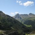
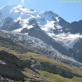
Continue along the pathway and cross a small wooden bridge. The path becomes much steeper and describes large stone laces. The view is plunging and changing as you climb up to the Lac du Glacier and its plateau is superb. After a last effort, one reaches the visible pass with the boulder placed on its crest. After a short descent, you win the Refugio Deffeyes and the Lago del Rutor. Note that it is possible to walk another five minutes to admire the small chapel of St Grato and St Margarita.
Descent
Take the same path as described above.
Photos of Lago del Rutor via Rutor Waterfalls and Lac du Glacier
")
")
")
")
")
")
")
")
")
")
")
")
")
")
")
")
")
")
")
")
")
")
")
")
")
")
")
")
")
")
")
")
")
")
")
")
")
")
")
")
")
")
Route
Download the route (KML) Download the route (GPX)
This post is also available in Français
About the Author
Pierre-Alexandre 33 ans, fondateur et webmaster de Randos-MontBlanc. Suivez-moi sur @pierrealexphotography