Hikes whose ascent lasts between two to three hours.
Browsing the "Ascent = 2-3 hours" Tag
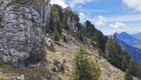
Roc des Boeufs
25 May 2021 | by Pierre-Alexandre
The Roc des Boeufs is located at the northern end of the Massif des Bauges on the western shore of Lake Annecy.The walk to the Roc des Boeufs should be done in dry weather as the climb through the forest can be very muddy and the arrival at the summit can quickly become very slippery.
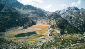
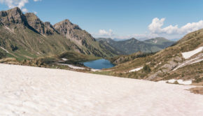
Lago del Rutor via Rutor Waterfalls and Lac du Glacier
21 September 2020 | by Pierre-Alexandre
Nestled in the Valle d'Aosta, Lago del Rutor is a little jewel of the Mont Blanc Massif. Indeed, it remains the object of a magnificent hike
Pointe de Talamarche
12 September 2020 | by Pierre-Alexandre
Pointe de Talamarche is a summit of the massif des Bornes culminating at an altitude of 1852m. Much less well known than the popular Tournette, Pointe de Talamarche is nevertheless a great idea
The Moléson
22 June 2020 | by Pierre-Alexandre
The Moléson is an emblematic mountain of the Fribourg Pre-Alps offering a prime hiking destination. Culminating at an altitude of 2002 m, the Moléson is very recognizable by its shape
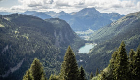
Lac Vert and Lac de Chésery via Portes du Soleil
22 May 2020 | by Pierre-Alexandre
Lac Vert and Lac de Chésery are two relatively unknown lakes in the Chablais massif. Nestled under Pointe des Mossettes and Pointe de Chésery, Lac Vert and Lac de Chésery constitute a charming hiking objective nevertheless. The hike I propose
Mont de Grange
2 August 2019 | by Pierre-Alexandre
Mont de Grange is one of the iconic peaks of the Chablais Massif. At an altitude of 2432 m (which is identical to that of the Cornettes de Bise), Mont de Grange dominates the Val d'Abondance in all its splendour. The panorama offered to the hiker is undoubtedly one of the most beautiful in
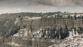
Creux-du-Van
7 May 2019 | by Pierre-Alexandre
The Creux-du-Van is a rocky cirque located in the Massif du Jura in the canton of Neuchâtel. 1.4 km wide and approximately 200 m high, the Creux-du-Van is one of the most picturesque sites in French-speaking Switzerland with its impressive walls sculpted by the erosion caused 18,000 years ago
Tête de Lindaret
10 October 2018 | by Pierre-Alexandre
Tête de Lindaret is a summit of the Chablais Massif, located in the south of the protected natural area of Mont de Grange. The toponym Lindaret limitaris meaning something "that makes limits or borders". Of intermediate difficulty, the itinerary I propose here describes a loop that starts from the Lindarets
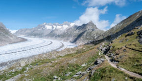
Aletsch Glacier
5 September 2018 | by Pierre-Alexandre
Located in the south of Switzerland, in the canton of Valais, the Aletsch glacier is the largest glacier in the Alps. Inscribed on the UNESCO World Heritage List in 2001, the Aletsch glacier will not leave the hiker indifferent in view of its characteristics : 81.7 km2 of surface, 22.6 km in length, 900 m in
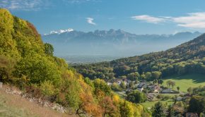
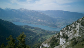
The Salève (via Etrembières)
13 October 2017 | by Pierre-Alexandre
The Salève is an emblematic summit of Haute-Savoie and the Geneva Basin, offering the walker a panorama of choice on the vast majority of the peaks of the region, as well as on Lake Annecy and Lake Geneva. A quick look at the map shows that several hiking routes are possible in order to climb
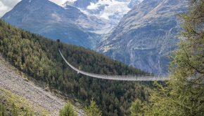
Charles Kuonen Suspension Bridge
20 August 2017 | by Pierre-Alexandre
The Charles Kuonen Suspension Bridge (or Charles Kuonen Hängebrücke in German) is located in Randa in the Valais Alps and is a must-see on the Europaweg trail from Grächen to Zermatt. The bridge is 494 meters long and weighs 58 tons and is the longest pedestrian suspension bridge in the
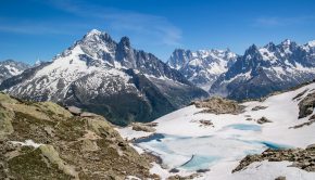
Lac Blanc (via the Col des Montets or Tré-le-Champ)
11 June 2017 | by Pierre-Alexandre
Must-see in the Chamonix Valley, Lac Blanc exhibits an unforgettable panorama on the Mont Blanc Massif. The itinerary described here offers a much more bucolic setting than the alternative route by the Flégère
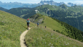
Randos les plus populaires


