Aletsch Glacier
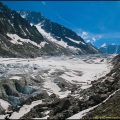
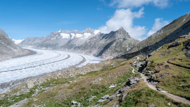
Located in the south of Switzerland, in the canton of Valais, the Aletsch glacier is the largest glacier in the Alps. Inscribed on the UNESCO World Heritage List in 2001, the Aletsch glacier will not leave the hiker indifferent in view of its characteristics : 81.7 km2 of surface, 22.6 km in length, 900 m in depth for a total weight of 27 billion tons ! To put the figures in perspective, if all the ice in the glacier were to melt, the resulting meltwater would be enough to supply every person on the planet with one litre of water per day for about six years.
Unfortunately, like many glaciers around the world, it is suffering from global warming. If the Aletsch glacier has lost about 2600 m since 1880, 30 % of this decline (or about 800 m) occurred between 1980 and 2010, indicating the acceleration of the glacier’s decline. Each year, the glacier loses up to 50 m in length. In addition, it was observed that the glacier reverses also in width. As such, I invite you to consult the comparative photo album of the Trient Glacier ; global warming is at work before our eyes, and if we do nothing to stop its course, these ice giants will be nothing more than memories that our children will not see.
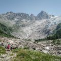
The route I propose here follows the classic panoramic trail (Panoramaweg) starting at the arrival station of the Moosfluh cable car and going to Märjelenseen in the north. The itinerary, which is bucolic to say the least, presents no difficulty, except perhaps the length of the itinerary with its 13.6 km round trip (hence its rating in the “Intermediate” category). The Matterhorn is one of the many peaks that can be admired during this outing. Note that the trail passes through Hohbalm, the lower part of the scenic path being closed for safety reasons. The last cable car connecting Moosfluh to the village of Riederalp leaves at 4.30 p.m., so you have to plan your outing carefully so as not to be caught short on the way back.
- Difficulty: Intermediate
- Altitude: 2,334 m at Moosfluh, 2,302 m at the Märjelenseen
- Outward Journey: 2 hours 30 min
- Return: 2 hours 00 min
- Elevation Gain: 320 meters
- Round-trip: 13.6 km
- Map: Carte nationale 1269 Aletschgletscher
Getting There
Reach Sierre by the motorway A9 then continue towards Brig-Glis. When you arrive in Brig-Glis, follow the road to Bitsch and then Mörel. In the village of Mörel, park on the left side of the road on the cable car parking lot. For users of public transport, take the Eurocity or Intercity to Brig, then take the Regio towards Fiesch and get off at Mörel.
The hike starts in Moosfluh (2334 m), the starting point of the panoramic path of the Aletsch Glacier. The ascent to the starting point is done in two stages: first, take a ticket for the cable car connecting Mörel ARBAG to Riederalp Mitte. Then, once at the arrival station, turn right and traverse the village of Riederalp to reach the cable car connecting Riederalp ARBAG to Moosfluh.
Aletsch Arena Cable car timetable.
Aletsch Arena Cable car fees
GPS Coordinates (WGS 84) of the Starting Point: 46.39580, 8.04829
Ascent
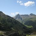
From the arrival station of the Moosfluh cable car, follow the direction of “Märjela Gletscherstube – 1 h 50” and the route 39 of Suisse Mobile. The scenic trail is relatively flat and passes two small lakes. Further on, a sign invites you to continue towards Hohbalm to reach Märjelenseen, the lower path being closed to the public. The path rises a little higher and then joins Hohbalm at the foot of the Bettmerhorn. From there, turn left and continue in the direction of “Märjela Gletscherstube – 2 h”.
The trail then loses altitude quite quickly until it intersects the lower road that is closed to hikers. The progression now takes place on a flat path giving the opportunity to admire the Aletsch Glacier. About an hour later, the path reaches the intersection of Roti Chumme. Once at the end of the panoramic path, it descends steeply towards Märjelenseen, the end point of the route.
Descent
Take the same path as described above.
Photos of Aletsch Glacier
")
")
")
")
")
")
")
")
")
")
")
")
")
")
")
")
")
")
")
")
")
")
")
")
")
")
")
")
")
")
")
")
")
Route
Download the paper route (PDF) Download the route (KML) Download the route (GPX)
This post is also available in Français
About the Author
Pierre-Alexandre 33 ans, fondateur et webmaster de Randos-MontBlanc. Suivez-moi sur @pierrealexphotography