Hikes of the 3431OT IGN Map.
Browsing the "3431OT IGN Map" Tag
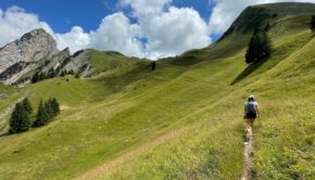
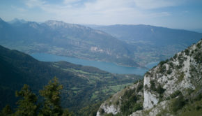
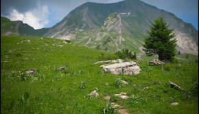
Pointe de Mandallaz (or Trois Aiguilles)
30 July 2023 | by Pierre-Alexandre
Pointe de Mandallaz (also known as the Trois Aiguilles) is located in the south-western part of the Aravis mountain range and rises to 2277m. Less well known than some of its neighbours, such as Mont Charvin
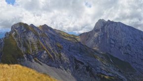
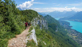
Pointe de Merdassier
24 August 2022 | by Pierre-Alexandre
Pointe de Merdassier is a summit located in the Aravis massif offering a 360° panorama on a large number of massifs, notably the Mont Charvin. The only access path to the summit of Pointe de Merdassier is very steep, perhaps the steepest I have encountered in many years
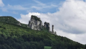
Chaos du Chéran
29 August 2021 | by Pierre-Alexandre
The Chaos du Chéran walk starts at the Pont de l'Abîme, a remarkable structure built in 1885 by Ferdinand Arnodin which links the village of Cusy to that of Gruffy above the Chéran. With a span of almost 75 metres and overlooking the Chéran by 96 metres, the view is breathtaking and superb
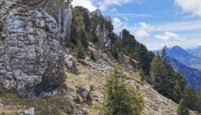
Roc des Boeufs
25 May 2021 | by Pierre-Alexandre
The Roc des Boeufs is located at the northern end of the Massif des Bauges on the western shore of Lake Annecy.The walk to the Roc des Boeufs should be done in dry weather as the climb through the forest can be very muddy and the arrival at the summit can quickly become very slippery.
Pointe de Talamarche
12 September 2020 | by Pierre-Alexandre
Pointe de Talamarche is a summit of the massif des Bornes culminating at an altitude of 1852m. Much less well known than the popular Tournette, Pointe de Talamarche is nevertheless a great idea
Praz Vechin and Col de l’Arpettaz
7 January 2019 | by Pierre-Alexandre
Located in the Aravis Range, Praz Vechin is a peak overlooking the Col de l'Arpettaz nestled at the foot of Mont Charvin. The term "Arpettaz" comes from the French word "alpe" which refers to a mountain pasture. The itinerary I propose here starts from the hamlet of La Penne
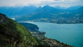
Mont Veyrier and Mont Baron
25 June 2018 | by Pierre-Alexandre
A great classic of the Massif des Bornes, Mont Veyrier is a summit that never ceases to impress walkers who come to walk on its slopes. Overlooking the village of Veyrier-du-Lac, Mont Veyrier is a magnificent belvedere on Lake Annecy, the Semnoz, as well as the peaks of the Aravis
Mont Baron (via the Col des Contrebandiers)
17 May 2015 | by Pierre-Alexandre
Located at the western end of the Bornes Massif just next to Annecy, Mont Baron remains an ideal goal for the preparation of the summer. Short and of slight elevation, the itinerary winds through the forest to emerge quickly on a balcony offering a beautiful view of Lake Annecy
Mont Charvin
14 July 2013 | by Pierre-Alexandre
Let’s get back to the Aravis Range to a place previously described in August 2007: Mont Charvin. If the lake was the objective of the last excursion, here you’ll have to climb the mountain overlooking the lake. Located at the end of the range between
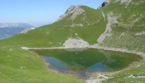
Lac du Mont Charvin
16 August 2007 | by Pierre-Alexandre
Located at the southern end of the Aravis Range, Mont Charvin dominates the town of Ugine. The Lac du Mont Charvin, nestled in a beautiful basin at the foot of the eponymous summit is the goal of this hike. There is no real difficulty: a very short and steep passage under the Col des Porthets and a brief
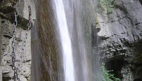
Waterfalls of Angon (Cascades d’Angon)
25 June 2006 | by Pierre-Alexandre
This outing is an ideal easy walk on a hot summer day, as the route exclusively takes place in the forest. The site of the Waterfalls of Angon (Cascades d’Angon) allows discovering a huge canyon by a very well-equipped trail with barriers
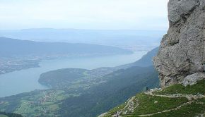
La Tournette
23 July 2005 | by Pierre-Alexandre
La Tournette is a superb spot to contemplate all the summits above Lake Annecy as well as the Aravis Range and the Mont Blanc Massif, sometimes hidden by the clouds when it's hot. This route is somewhat technical in its final part, as many passages are equipped with cables and
12
Randos les plus populaires


