Pointe de Mandallaz (or Trois Aiguilles)
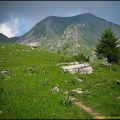
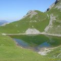
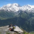
Pointe de Mandallaz (also known as the Trois Aiguilles) is located in the south-western part of the Aravis mountain range and rises to 2277m. Less well known than some of its neighbours, such as Mont Charvin and Pointe de Tardevant, Pointe de Mandallaz is nevertheless an ideal summit for a family hike, either at the beginning or end of the season. The scenery on the way up is varied (forest, meadows and even a small lake), while the panorama from the summit offers a very wide view of the Mont Blanc massif.
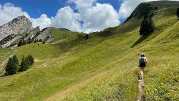
The route I am proposing here is not technically difficult (no dangerous or exposed sections) and has a regular altitude profile with no really steep sections (with the exception of the last 900 metres of the ascent from the col before the summit). However, the last few metres of the ascent to the “true summit” are quite exposed. Given that the view is almost identical a little lower down, I think you can make do with the subpeak.
Please note that although dogs are permitted, they must be kept on a lead. In addition, bivouacking is strictly prohibited throughout the area in accordance with the municipal by-law of 6 July 2022.
- Difficulty: Intermediate
- Altitude: 2,277 m
- Ascent: 3 hours 00 min
- Descent: 2 hours 30 min
- Elevation Gain: 1,120 meters
- Round-trip: 12.3 km
- Map: IGN 3431 OT
Getting There
Departure from the “La Joux” car park, at the end of the Route de l’Aiguille, south-east of Manigod.
GPS Coordinates (WGS 84) of the Starting Point: 45.830484, 6.417474
Ascent
From the car park, follow the sign to “Pointe de Mandallaz – 3 h 35”. The route climbs steadily along an undergrowth path strewn with stones. At the first junction, turn right or left (the right-hand path runs alongside the river and is slightly shorter). The path then becomes fairly gentle and continues through the forest. After crossing the bridge, turn left towards “L’Aulp de Marlens – 3 h 35” as indicated by the sign.
The path now becomes steeper and twists and turns a few times. Note that the path is marked with a few yellow arrows. Further on, the path emerges from the forest. It offers a clear view of the Pointe de Mandallaz on the left and Mont Charvin opposite. You then reach Sous le feu, where you have to follow the signs for “l’Aulp de Marlens – 2 h 45”. A few metres later, keep to the left to follow the sign for “Pointe de Mandallaz – 2 h 20”.
The path then climbs quite steeply into the alpine pasture where cows and sheep graze. You will then reach the Chalet de l’Aulp de fier d’en bas. Go around the chalet to the right. The path descends slightly before climbing back up into the pasture. After a bit of effort, the path passes behind a knoll on the other side of the mountain pasture; Pointe de Mandallaz is now clearly in sight.
Continue along the sloping path in the pasture, which becomes rolling and then steep again. Further on, you reach the small pass via a somewhat steep climb before the final ascent to the summit.
This final ascent is steep, but the scenery at the summit will make you forget the effort. It is not necessary to reach the “real” summit as the final part of the path is quite exposed.
Descent
Take the same route as above.
Photos of Pointe de Mandallaz (or Trois Aiguilles)
")
")
")
")
")
")
")
")
")
")
")
")
")
")
")
")
")
")
")
")
")
")
")
")
")
")
Route
Download the route (KML) Download the route (GPX)
This post is also available in Français
About the Author
Pierre-Alexandre 33 ans, fondateur et webmaster de Randos-MontBlanc. Suivez-moi sur @pierrealexphotography