Mont Veyrier and Mont Baron
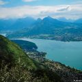
A great classic of the Massif des Bornes, Mont Veyrier is a summit that never ceases to impress walkers who come to walk on its slopes. Overlooking the village of Veyrier-du-Lac, Mont Veyrier is a magnificent belvedere on Lake Annecy, the Semnoz, as well as the peaks of the Aravis and Bauges Massif.
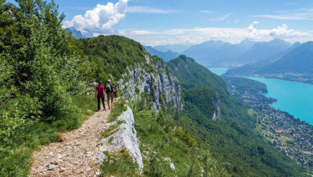
The hike that I propose here describes a circuit that reaches, first, the Mont Veyrier from the Pré Vernet and continues towards the Mont Baron, and then, in a second time, goes down towards the Creux du Loup and the Pré Vernet. The route has no particular difficulties. The descent from Mont Baron is quite steep and can be tricky in the following days of rain on the passages intertwining roots and rocks worn by erosion. I would also like to point out that the trail is exposed in certain places; be careful before taking pictures and keep an eye on your children. Walkers who wish to reach Mont Veyrier from the south-east can consult the route from Mont Baron via the Col des Contrebandiers.
- Difficulty: Intermediate
- Altitude: 1,291 m at the Mont Veyrier, 1,299 m at the Mont Baron
- Ascent: 1 hour 30 min
- Descent: 0 hour 55 min
- Elevation Gain: 540 meters
- Round-trip: 5.1 km
- Map: IGN 3431 OT
Getting There
Since the decree of 26 July 2024 by the Mayor of Veyrier-du-Lac, it is no longer possible to use the route forestière du Mont Baron.
For parking, you’ll have to park on the Petit Port side of Annecy-le-Vieux. You can also take the bus from Annecy to Veyrier-du-Lac: bus route 20 is free from 1 July to 31 August.
GPS Coordinates (WGS 84) of the Starting Point: 45.908321, 6.172575
Ascent
From the Pré Vernet, take the path on the right towards Mont Veyrier and Mont Baron via the Col des Sauts. One will notice on the right a spruce tree with remarkable growths to say the least; baptised “Monument of the twentieth century” by an anonymous, the very suggestive form of the trunk is indeed regularly observed in trees prone to attacks such as insect bites or the presence of obstacles (stones, ancient stumps, etc.). In this way, the tree can hide the pathogen1.
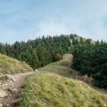
The path rises fairly quickly in the forest by more or less tight switchbacks. The course is marked by red and yellow stripes as well as red dots on the stones and trees. After several minutes of climbing, one reaches a first point of view with a bench offering a splendid perspective on Annecy and its lake. Further on, the trail reaches the Col des Sauts where one can contemplate the splendid panorama over Lake Annecy, the Semnoz and the Tournette and the Bauges peaks. From there, follow the direction of Mont Veyrier as indicated by the sign.
The path continues to meander through the forest, then flattens somewhat. Later, the Sentier des Crêtes leads to an impressive balcony where one can only admire, once again, the beauty of Lake Annecy below. After about an hour and a half of effort, Mount Baron is reached.
Descent
From Mont Baron, take the direction of Pré Vernet by Le Creux du Loup. The descent is well signposted, as yellow arrows indicate the descent to the Pré Vernet.
Photos of Mont Veyrier and Mont Baron
")
. (24 juin 2018)")
")
")
")
")
")
")
")
")
")
")
")
")
")
")
")
Route
Download the route (KML) Download the route (GPX)
- Rougier, Henri. Arbres remarquables de Haute-Savoie: Du Mont-Blanc au Léman. Pontarlier : Editions du Belvédère, 2016, p.66 ↵
This post is also available in Français
About the Author
Pierre-Alexandre 33 ans, fondateur et webmaster de Randos-MontBlanc. Suivez-moi sur @pierrealexphotography