Praz Vechin and Col de l’Arpettaz
Located in the Aravis Range, Praz Vechin is a peak overlooking the Col de l’Arpettaz nestled at the foot of Mont Charvin. The term “Arpettaz” comes from the French word “alpe” which refers to a mountain pasture. The itinerary I propose here starts from the hamlet of La Penne in Ugine and goes along the Meuneray stream to go up towards the farm of the hamlet called “Baru” and then to the locality called “Retorney”.
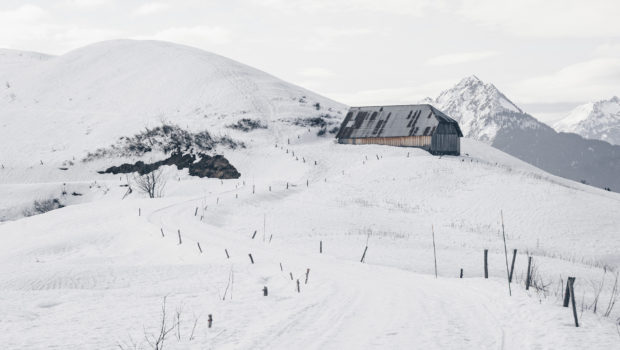
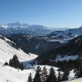
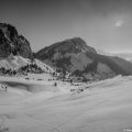
Then, it is a time to climb the steep slopes of Praz Vechin and finally reach a viewpoint indicator offering a magnificent view of the Beaufortain and Aravis Range. However, hikers looking for a gentle end to the route can simply walk to the Col de l’Arpettaz and its refuge. The Refuge du Col de l’Arpettaz is open in winter and has a restaurant (but only on reservation). After so much effort, a little raclette break is well deserved! Furthermore, the route is of intermediate difficulty due to the length of the route for a snowshoe outing and the cumulative gain to reach Praz Vechin.
- Difficulty: Intermediate
- Altitude: 1,743 m at Praz Vechin, 1,581 m at the Col de l’Arpettaz
- Ascent: 1 hour 30 min for Praz Vechin and the Col de l’Arpettaz
- Descent: 1 hour 00 min from both points
- Elevation Gain: 600 m for Praz Vechin, 470 m for the Col de l’Arpettaz
- Round-trip: 8,0 km for Praz Vechin, 8,5 km for the Col de l’Arpettaz
- Map: IGN 3431 OT
Getting There
From Megève, follow the direction of Flumet. After passing Flumet, after a few kilometres, turn right at an intersection towards “Les Annuits” and “Les Praz”. Follow the winding road until you reach the small car park in the hamlet of La Penne on the left of the road.
GPS Coordinates (WGS 84) of the Starting Point : 46.123940, 6.711144
Ascent
From La Penne car park, first take the road to an intersection. There, you have to turn right to take the road up the slope and leave the road to the left. The road then rises regularly and reaches a sign where you will follow the direction of Baru. Orange dots on the trees and stakes serve as markers throughout the ascent.
The path then passes on the right the chalets des Mermets then the chalets de la Montagnette. Further on, turn right as indicated by the orange arrow painted on a tree. The footpath then rises steeply enough on the slope and leave the forest shortly afterwards. The trail then climbs up the slope and reaches the farm of the locality “Baru” which already offers a magnificent panorama over the Beaufortain. Go around the farm on the left and continue to follow the orange marking and cross the asphalt road to continue climbing the slope. After a relatively steep climb, you reach the place called “Le Retorney” at the foot of Praz Vechin.
From there, the hiker has two options: either simply continue on the paved road to the Col d’Arpettaz and its refuge. The refuge is then reached without any particular effort in about twenty minutes. Or, to make the hike a little more picturesque, turn right and follow the direction “Praz Vechin – 0:40” as indicated by the sign at the Retorney. The path is steep enough and winds down the slope to slip through the trees. After about forty minutes, Praz Vechin is reached. The viewpoint indicator at the top is also an opportunity for the walker to discover the Beaufortain and Aravis mountains. From there, you can then go down to the Retorney and continue to the Col de l’Arpettaz and its refuge to enjoy a well-deserved raclette!
Descent
Take the same path as mentioned above.
Photos of Praz Vechin and Col de l’Arpettaz
")
")
")
")
")
")
")
")
")
")
")
")
")
")
")
")
")
")
")
")
")
")
")
")
")
")
")
")
")
")
")
")
Route
Download the route (KML) Download the route (GPX)
This post is also available in Français
About the Author
Pierre-Alexandre 33 ans, fondateur et webmaster de Randos-MontBlanc. Suivez-moi sur @pierrealexphotography


This is a beautiful winter hike! To reach the turn-of to ‘Les Annuits’, make sure to follow the signs for Hery sur Ugine after Flumet instead of the main road to Ugine. From Praz Vechin, it is possible to make a loop by going down on the other shoulder of the peak to Bellieuvres Ruines, and continue along the ridge.