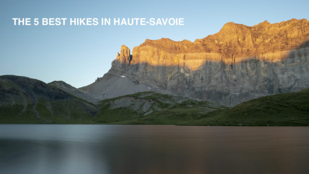
The 5 Best Hikes in Haute-Savoie
At the heart of the majestic French Alps, Haute-Savoie is a treasure trove for nature lovers and hiking enthusiasts. Its breathtaking landscapes, with snow-capped peaks, crystal-clear lakes and verdant valleys, provide a breathtaking backdrop for adventurers in search of escape. In this article, I take you on a journey to discover the five most exceptional walks in Haute-Savoie, in my opinion. Each one will bring you a little closer to the natural splendour that defines this iconic region.
Choosing just five of Haute-Savoie’s countless majestic trails was no easy task. Every nook and cranny of this land is full of striking panoramas and vistas that will leave you in awe. Nevertheless, after some thought, I’ve managed to compile a list, albeit a very subjective one, that captures the very essence of the department’s beauty.
Get ready to plunge into a world of wild nature and breathtaking horizons:
Lac Blanc (via Col des Montets or Tré-le-Champ) : a classic of Haute-Savoie
I’m probably repeating myself, but I don’t think I’m wrong in putting Lac Blanc at the top of this list. Yes, it has to be said straight away that it’s very busy in high season (between late June and late August). But the scenery along the way is one of the most beautiful I’ve come across on any of my hikes. A must for Haute-Savoie!
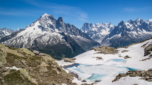
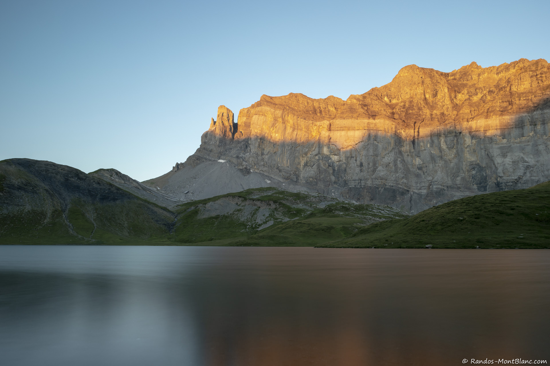
Located in the heart of the Aiguilles Rouges Nature Reserve, Lac Blanc rises to an altitude of 2352 metres. It consists of a lower section around three metres deep and an upper section around ten metres deep. The waters of Lac Blanc flow into a torrent that joins the Arve downstream, to the north of Chamonix. It should be noted that the rear part of the lake remains snow-covered until well into the summer (mid-August). However, due to global warming, the ice and snow in this rear section is melting earlier and earlier (late June, early July).
When you finally reach Lac Blanc after almost three hours of effort, the view is absolutely breathtaking. The peaks of the Mont Blanc Massif seem almost within reach! There are two ways to reach the lake: from La Flégère or from the Col des Montets or Tré-le-Champ. The route via La Flégère involves using its characteristic gondola lift, followed by a walk of less than two hours to Lac Blanc. In my opinion, it’s better to opt for the alternative starting at Col des Montets or Tré-le-Champ. These two routes are much wilder and less frequented than the one via La Flégère.
Difficulty : Hard ![]()
Altitude : 2,352 m
Ascent: 2 hours 45 min for both routes
Descent: 1 hour 30 min via Tré-le-Champ’s path / 2 hours 00 min via the Col des Montets’s path
Elevation Gain: 990 meters via Tré-le-Champ’s path / 970 m via the Col des Montets’s path
Round-trip: 8.0 km via Tré-le-Champ’s path / 9.4 km via the Col des Montets’s path
Restrictions : Dogs (even on a leash) and gathering prohibited. Bivouac allowed between 7 pm and 9 am.
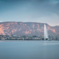
Balcon des Mémises : an incredible view of Lake Geneva
The Balcon des Mémises (or Montagne des Mémises as the IGN map indicates) is a family hike par excellence, alternating between plains, forests and ridge paths (fortunately not exposed!). I remember the Mémises as being one of the first hikes I had to do when I was younger. The scenery from the path along the ridge is one of the most impressive in Haute-Savoie, with the view of Lake Geneva seemingly within reach. On foggy days, you get the impression that Lake Geneva is a sea rather than a lake when you can’t see the opposite shore.
The route offers two possibilities: one, a little difficult via the échelle des Chasseurs, which can be impressive at first glance, and the other, easier via the Col de Pertuis, which offers no technical difficulties. I strongly recommend taking this second option, which I think is more suitable if you are afraid of heights.
Difficulty : Intermediate ![]()
Altitude : 1,674 m
Route : 3 hours 00 min
Elevation Gain : 570 meters via the ladder / 550 meters via the alternative route
Round-trip : 10.1 km via the ladder / 9.4 km via the alternative route
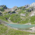
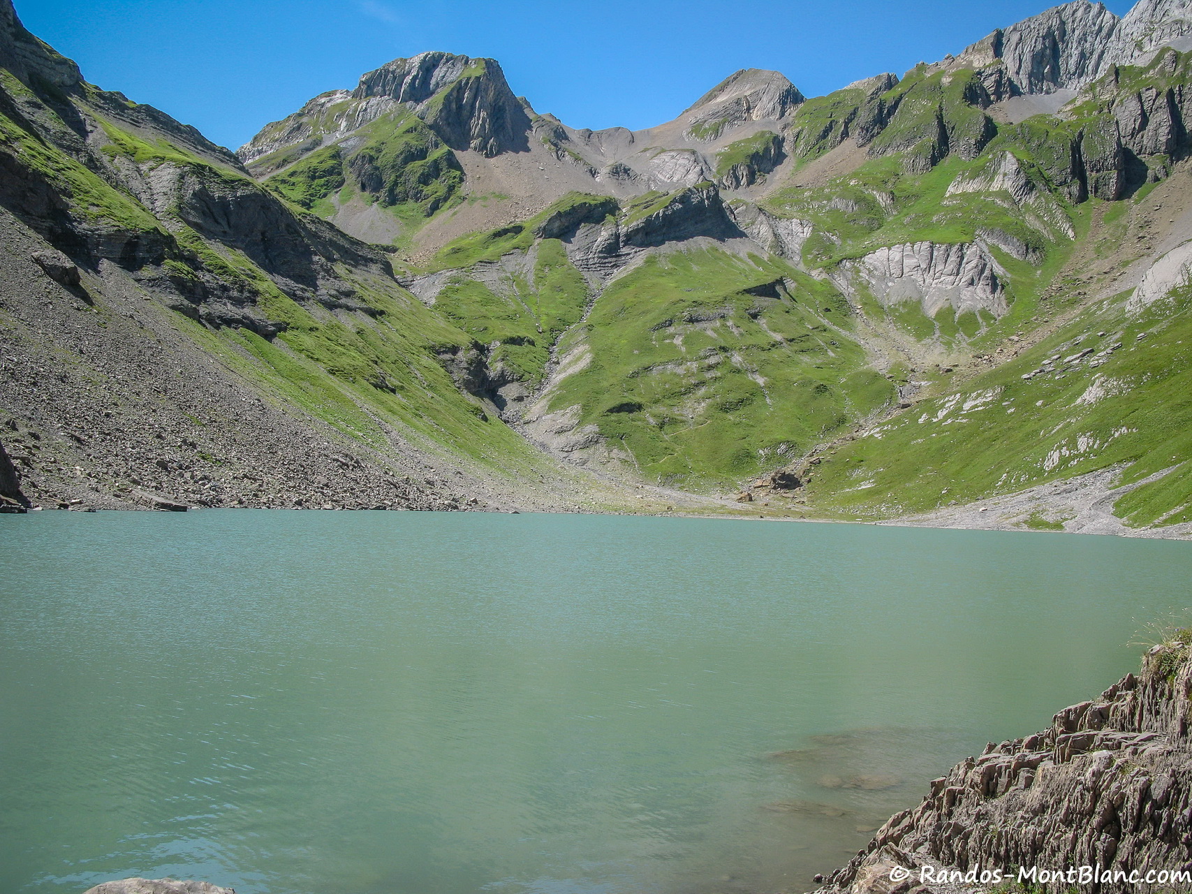
Col and Lac d’Anterne : an unforgettable bivouac experience
Nestling in the heart of the Sixt-Passy nature reserve, Lac d’Anterne emerges like a glistening pearl of azure from a wilderness setting. The lake rises from a glacial cirque sculpted with artistic precision by the age-old forces of nature. The imposing peaks that surround it create a striking contrast with the limpid tranquillity of the waters. The hauntingly clear waters of the lake faithfully reflect the changing skies and towering mountains that stand proud.
When the sun is at its zenith, sparkling reflections dance across the surface, creating a living canvas of light and colour. Peace reigns supreme here, disturbed only by the gentle murmur of the wind caressing the surface of the water. Hikers and nature lovers find refuge in this serene haven, marvelling at the raw, timeless beauty that surrounds them.
Lac d’Anterne was one of my first bivouac experiences in Haute-Savoie. The orange morning light over the Rochers des Fiz will remain an unforgettable memory! The route to the lake and the Col d’Anterne beyond requires a certain amount of physical effort and is not for everyone. The climb can be quite strenuous at times, and it is crucial to make the ascent in the morning or evening to avoid the stifling afternoon heat. However, the panoramic views from the lake and the Col d’Anterne will make you forget the effort.
Difficulty : Difficile ![]()
Altitude : 2,257 m at the Col d’Anterne
Ascent : 3 hours 30 min to get to the Lac d’Anterne + 45 min to reach the Col d’Anterne
Descent : 3 hours 00 min
Elevation Gain : 1,190 m
Round-trip : 17.4 km
Restrictions : Dogs (even on a leash) and gathering prohibited. Bivouac allowed between 7 p.m. and 9 a.m.
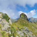
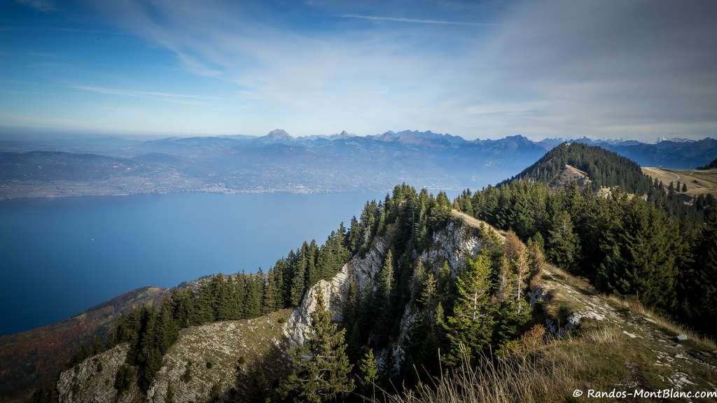
Mont Veyrier and Mont Baron : an exceptional panorama
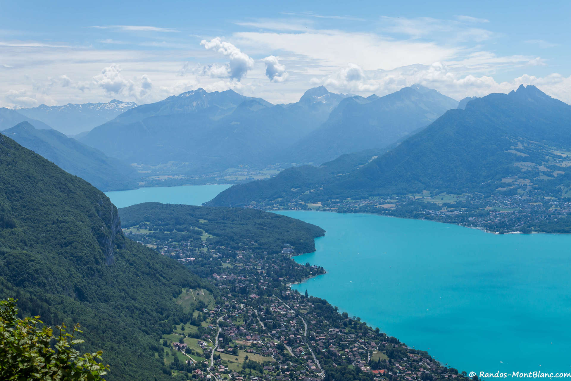
The ascent to the summit of Mont Veyrier and Mont Baron is much more than a simple hike: it’s a journey through a diversity of sensations and panoramas. The path winds its way through dense woods before leading to a ridge path (from which you need to be careful) that is surely one of the most beautiful in Haute-Savoie. Once at the top, the reward is a breathtaking view. The turquoise waters of Lake Annecy stretch out before you, surrounded by the peaks of the Bornes massif on one side and the Bauges massif on the other. The sunsets from Mont Veyrier and Mont Baron are a sight not to be missed. The last rays of the day set the sky ablaze and tint the peaks with a palette of warm, golden colours, creating a magical, romantic atmosphere.
The route I suggest has no particular difficulties, except that you’ll need to keep a careful eye on the ridge path, which can be slippery the day after it rains.
Difficulty : Intermediate ![]()
Altitude : 1,291 m at the Mont Veyrier, 1,299 m at the Mont Baron
Ascent : 1 hour 30 min
Descent : 0 hour 55
Elevation Gain : 540 meters
Round-trip: 5.1 km
Lac de la Vogealle : a jewel of Haute-Savoie
To finish this list, I’d like to suggest another lake in the heart of the Haut-Giffre massif: Lac de la Vogealle. This small lake, perched at an altitude of 2001m, is surrounded by the Dents Blanches and offers a beautiful view of numerous peaks over 3000m, including Mont Buet. A hike to Lac de la Vogealle is an unforgettable experience, as the route passes through the Cirque du Fer-à-Cheval. This cirque, protected by the Sixt-Passy nature reserve, includes several waterfalls and is a prime vantage point for observing the wildlife of Haute-Savoie.
The route is not for everyone. It is very long (almost 20 km round trip) via Le Bout du Monde. I strongly advise against climbing via the Pas du Boret, as this is a very technical route and can quickly become dangerous in wet weather.
Difficulty : Hard ![]()
Altitude : 2,001 m
Ascent : 3 hours 50 min
Descent : 2 hours 40 min
Elevation gain : 1,300 meters
Round-trip: 19.7 km
This post is also available in Français
About the Author
Pierre-Alexandre 33 ans, fondateur et webmaster de Randos-MontBlanc. Suivez-moi sur @pierrealexphotography