Pic de la Corne
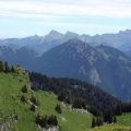
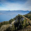
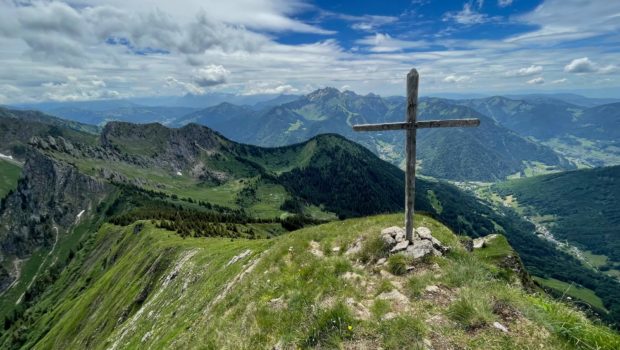
Pic de la Corne is a rather unknown summit in the Chablais massif. From the top of its 2084 m of altitude, Pic de la Corne is nevertheless an interesting hiking objective. Indeed, it offers the hiker a splendid panorama on the peaks of the Chablais (such as Mont de Grange) but also on Lake Geneva and Dents du Midi.
The itinerary I propose is common to the Roc and Lac de Tavaneuse on a good section of the route. There is no difficulty to report except for the significant elevation (930 m) over such a short distance (3.8 km). On the other hand, there are no dangerous passages, except for the part of the ridge located after the cross marking the southern summit (the northern summit about 50 metres away is actually inaccessible; it is useless and dangerous to go there because of the breach). I therefore recommend this route to well-trained hikers. Finally, I strongly advise to do this outing only in dry weather. The ascent of Col de Damoz des Moulins is very steep (average slope of 33%) and wet terrain can make it very difficult to descend.
It should be noted that the hike can be done from the Lac de Damoz des Moulins on the St-Jean-d’Aulps side. For the curious, the toponym Pic de la Corne probably describes a rocky point or an elongated area 1.
- Difficulty: Intermediate
- Altitude: 2,084 m
- Ascent: 2 hours 40 min
- Descent: 1 hour 50 min
- Elevation Gain: 930 meters
- Round-trip: 7.6 km
- Map: IGN 3528 ET
Getting There
Go to the place called “Prétairié” after Abondance and park in the car park at the end of the road.
GPS Coordinates (WGS 84) of the Starting Point: 46.250270, 6.721645
Ascent
Take the gravel path that rises gradually along the river. Further on, at the intersection of Dessus la Chargne, turn right at the sign for “Col de Damoz des Moulins – 2 h 00”. The path then becomes much steeper in the undergrowth. After a steady climb, you reach the two chalets of Les Serranants and their mountain pasture. The latter already offers a nice view of Pic de la Corne on the right and the waterfall of the Tavaneuse stream on the left.
Then, continue to advance to reach a wooden fence delimiting the cow enclosure. From there, follow the direction of the “Col Damoz des Moulins – 1 h 30” located just opposite. The path flattens out considerably. A few moments later, turn right to go towards the “Col Damoz des Moulins – 1 h 25” and the eponymous combe twenty minutes away. The path continues through a magnificent meadow strewn with many dandelions. The path then skirts the fir-covered knoll on the right that could be seen from the previous intersection.
Further on, you reach a signpost indicating the Combe de Damoz des Moulins. From here, turn right to go towards the “Col de Damoz des Moulins – 1 h 05”. The path climbs very steeply via short switchbacks below the pass in sight. The effort is sustained until the pass where a well-deserved break is necessary.
From the pass, follow the path along the edge of the forest to climb towards Pic de la Corne. Note that the summit is not indicated by the sign at Col de Damoz des Moulins. The path is well marked and rises gradually at the edge of the forest towards the summit. A little further on, Pic de la Corne and its cross are clearly visible. A final effort and the summit is reached with its incredible panorama.
Descent
The descent is made by the same route as the ascent.
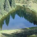
Photos of Pic de la Corne
")
")
")
")
")
")
")
")
")
")
")
")
")
")
")
")
")
")
")
")
")
")
")
")
")
")
")
")
")
")
")
")
")
")
")
Route
Download the route (KML) Download the route (GPX)
- Buord, Jean-Philippe. Origine des noms des montagnes de la Haute-Savoie. Annecy : Color Verba Edition, 2015, p.127 ↵
This post is also available in Français
About the Author
Pierre-Alexandre 32 ans, fondateur et webmaster de Randos-MontBlanc. Suivez-moi sur @pierrealexphotography