Aiguilles de Baulmes
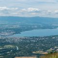
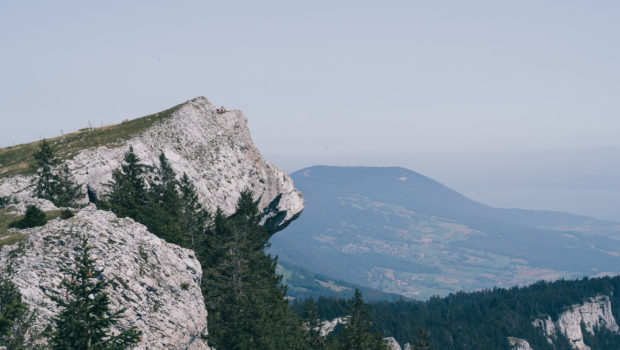
Aiguilles de Baulmes is a group of crests located in the Jura massif in the district of Jura-nord vaudois. Culminating at an altitude of 1558 m, Aiguilles de Baulmes are a great classic of the region. Indeed, the path along the ridge offers a magnificent 180° panorama of the Alps, Lake Neuchâtel and Lake Geneva.
The itinerary proposed here starts at the train station of Ste-Croix and initially joins the hamlet of Culliairy by an asphalt road. Then the main part of the ascent in the forest begins. Good physical fitness is required as the average slope is about 24%. The path then reaches the ridge and its breathtaking view. The return to Ste-Croix is more pleasant for the feet as the trail progresses on a plateau after a short descent in the undergrowth.
The toponym “Baulmes” refers to the eponymous village below. It is said to have originated from Barm, then Balm and Balma designating a hole or a cave.
- Difficulty : Intermediate
- Altitude : 1,558 m
- Ascent : 1 hour 50 min
- Descent : 1 hour 20 min
- Elevation Gain : 710 m
- Round-trip : 10,6 km
- Map : Carte nationale 1182 Sainte-Croix
Getting There
Go to Ste-Croix and come and park at the station car park. For public transport users, first go to Yverdon-les-Bains and then change for the Regio train going up to Ste-Croix.
GPS Coordinates (WGS 84) of the Starting Point : 46.81970, 6.50052
Ascent
From the station, follow the signs for Aiguilles de Baulmes. Cross the railway line to take the Rue de la Sagne. Further on, at an intersection, turn left towards “Aiguilles de Baulmes – 1 h 40” to take the Route de Culliairy.
The road then joins the hamlet of Culliairy. Shortly afterwards, turn right to leave the asphalt road and take the path going into the forest and up towards “Aiguilles de Baulmes”. Yellow rhombuses painted on the trees indicate the pathway to follow. The progression is quite steep, irregular and the effort is sometimes intense.
Once you reach a crossroads, turn left towards “Cave Noire – Aiguilles de Baulmes (sentier à 200 m)” as mentioned by the sign. Then, after about one minute of descent, turn right. The path then resumes its progression through the woods.
The trail then joins the ridge and continues along it. It should be noted that it is possible to visit the Cave Noire; in this case, turn left at the sign “Cave Noire à 50 m – passage dangereux”. The passage is quite steep on a ledge, but has a cable to get over the obstacle safely. A torch is compulsory to explore the cave.
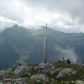
Back on the main path, the progression flattens out and later reaches a superb open plateau with a splendid view of the Alps, Lake Neuchâtel and Lake Geneva. When walking across the ridge, always take the path furthest to the left (ignore the path going to the right at an unmarked bifurcation). A little further ahead, turn left in the direction of “Sommet – 5 min”. You will then reach the “real” summit of Aiguilles de Baulmes with its cross at an altitude of 1558m.
Descent
Follow the direction of Jougne (France) and the Col de l’Aiguillon as indicated by the sign. The footpath descends quite steeply into the forest by short bends. Continue then straight on towards Ste-Croix and Gittaz when you reach two intersections. A little further on, you arrive on a grassy plateau where the cows graze.
Always follow the yellow markings. The path is now flat and then resumes its progression through the undergrowth. Continue to finally reach Ste-Croix and the asphalt road taken on the outward journey.
Photos of Aiguilles de Baulmes
.")
.")
.")
.")
.")
.")
.")
.")
.")
.")
.")
.")
.")
.")
.")
.")
.")
.")
.")
.")
.")
.")
.")
.")
.")
.")
.")
.")
.")
.")
.")
.")
.")
.")
.")
Route
Download the paper route (PDF) Download the route (KML) Download the route (GPX)
This post is also available in Français
About the Author
Pierre-Alexandre 33 ans, fondateur et webmaster de Randos-MontBlanc. Suivez-moi sur @pierrealexphotography