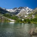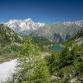
Lake Licony and Col de Licony
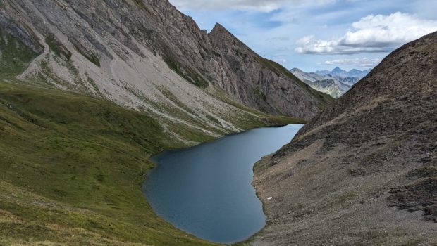
Located in the Val d’Aosta near Courmayeur, Lake Licony is one of the largest natural lakes in the region. Nestling in a basin, the changing colours in the sunlight transform Lake Licony into a veritable jewel. The route I propose continues to the Col de Licony, which offers a magnificent view of the whole lake on one side and the Val Sapin on the other. From here, hikers can admire the whole of the Mont Blanc massif.
Although the route presents no technical difficulties, it is classified as “Difficult”. Even if the positive elevation gain doesn’t seem so great at first glance, the round trip distance is considerable (17.5 km) and requires good training. What’s more, the climb up to the pass just before Lake Licony is very steep and requires a very sustained effort.
- Difficulty: Hard
- Altitude: 2,555 m for Lake Licony, 2,670 m for the Col de Licony
- Ascent: 3 hours 20 min for the lake, 3 hours 50 min for the col
- Descent: 2 hours 40 min from the col
- Elevation Gain: 1,240 meters
- Round-trip: 17.5 km
- Map: Carte nationale 292 Courmayeur
Getting There
From Courmayeur, head for Morgex then La Salle and continue towards Planaval. Go past Morge la Salle, pass the 1st car park and stop after the right-hand hairpin at a 2nd car park with around ten spaces at “Plan Belle Crête”. The path starts just on the other side of the road.
GPS Coordinates (WGS 84) of the Starting Point: 45.770809, 7.068747
Ascent
From the car park, follow the signs for “Col de Licony – 3 h 50”. After a short flat section in the forest, the path descends steeply for around 200 metres to a bridge that you need to cross. A little further on, you come to a chalet, which you should walk around until you come to a sign. Follow the signs for “Col de Licony – 3 h 30”. The wide path continues through the woods and then narrows to reach a small waterfall, which you must cross. Follow the path along the valley, from where you can see the rest of the route on the other side. Once you reach a fork in the path, take the lower path signposted “Licony – 0 h 35”. You then cross the Chambave torrent. Large stones and a secure handrail help you cross the torrent safely.
Continue along the path, which now opens out onto a vast alpine pasture. A little further on, the route joins a track reserved for local residents. Follow the signs for “Col de Licony – 2 h 25” to reach the hamlet of Licony. It is from here that most of the climb is completed. At the signpost, continue towards “Lago Licony – 1 h 45” and “Colle di Licony – 2 h 10” along the wide track, which you should leave after a few metres to follow the yellow arrows painted on the rocks. A narrow, steep path gets steeper and steeper and leads to a waterfall, which you leave to the right. A small pass comes into view, with the lake just beyond.
The climb up to this pass is very steep and the path is quite rocky in places. The effort is real, but is quickly forgotten once you reach Lake Licony. Fortunately, the ascent to the Col de Licony is much easier. The path skirts around the lake to the right. After a short climb, it bends left for a long, gentle traverse. The Col de Licony is then reached very quickly.
Descent
Take the same path as on the way up. However, after the hamlet of Licony, be careful to take the path on the left at the fork in the direction of Morge (la Salle).
Photos of Lake Licony and Col de Licony
")
")
")
")
")
")
")
")
")
")
")
")
")
")
")
")
")
")
")
")
")
")
")
")
")
")
")
")
")
")
")
")
")
")
")
")
")
")
")
")
")
")
")
")
")
")
")
")
Route
Download the paper route (PDF) Download the route (KML) Download the route (GPX)
This post is also available in Français
About the Author
Pierre-Alexandre 33 ans, fondateur et webmaster de Randos-MontBlanc. Suivez-moi sur @pierrealexphotography