Bivouac du Petit Mont Blanc
Let’s go to Italy in the Val Veny to do an outing that will stay in your mind forever: the Petit Mont Blanc Bivouac (or Rifugio Rainetto).
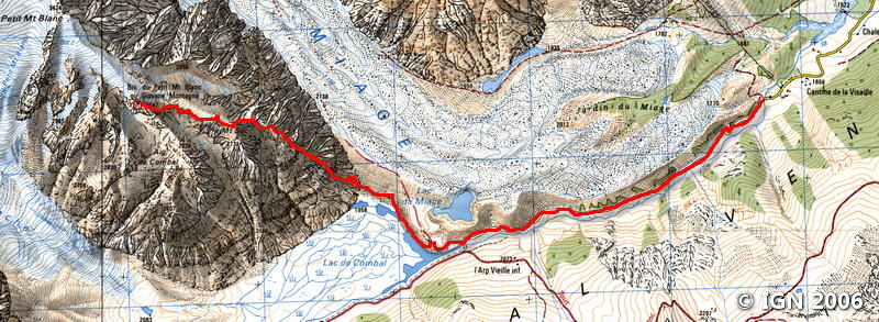
The starting altitude (1,670 m) and the finish at 3,047 m at the Petit Mont Blanc Bivouac set the scene.
If the hike starts on a good paved road to the Lac de Combal, it is quite different afterward.
The trail is narrower and quickly reaches a very steep valley between Mont Suc and the Aiguille de Combal.
The 1,350 m of elevation gain are ascended by a small path that wanders between the rocks. The marking, although present, requires special attention so as not to get lost in the succession of more or less easy rocky passages.
A late névé imposes vigilance when crossing it.
The end of the ascent is very steep and requires a safe foot to climb some exposed passages.
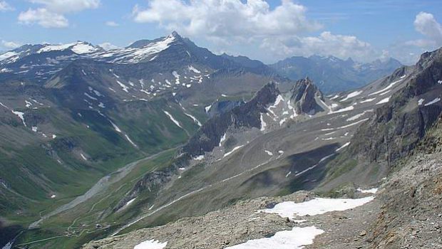
The Glacier and Lac de Miage, Aiguille Noire de Peuterey, limestone pyramids, Aiguille des Glaciers or the Gran Paradiso are some of the wonders to discover during this itinerary intended for experienced hikers accustomed to evolve between 2,000 m and 3,000 m who have a good physical condition and are not afraid of exposed passages.
Note the peculiarity of the Lac Combal that stems from the melting of the glaciers; It’s a kind of marsh where glacial deposits have accumulated and force the water to meander along the slope.
The Lac de Miage with its particular color is accessible to the right of the Bar de Combal. It is formed in a pocket of the glacier from which it is fed.
Piolet and rope are not mandatory, but they can be useful according to the season.
- Difficulty: Very Hard
- Altitude: 3,047 m
- Ascent: 4 hours 00 min
- Descent: 3 hours 00 min
- Elevation Gain: 1,400 meters
- Round-trip: 13.5 km
- Map: <b>IGN 3531 ET</b>
Getting There
From Chamonix, take the Mont Blanc tunnel. At the exit, take the direction of Entrève – Val Veny (which is the first valley on the right out of the tunnel).
Follow the road until the end of the road at the Visaille. Park in the parking lot at the Visaille or along the road by doing a U-turn at the gate.
GPS Coordinates (WGS 84) of the Starting Point : 45.785682, 6.899554
Ascent
From the barrier, continue the paved road for about 30 minutes to Bar de Combal.
Turn left along the marked road “Rifugio Rainetto” following the end of the marshes forming the Lac de Combal.
At the bottom of the Combe, the path is transformed and goes up by very tight switchbacks: follow the yellow markings “N ° 14” present on the blocks. After passing the creek that descends from the summit, the route becomes more perilous.
A rather steep late névé blocks the center of the valley at the foot of a waterfall; It must be traversed on the right to join the markings visible on the rock. Beware of the very deep rimaye at this place on the edge of the waterfall.
Pass the névé, cross the waterfall that grows over the day, and continue through the blocks.
After a jump, a plateau allows admiring a splendid panorama on the Gran Paradiso.
Continue the ascent of the large rock blocks to a small plateau where you can see the red hut next to the metal cross.
Continue the progression by skirting on the right and reaching the final ridge leading to the Bivouac du Petit Mont Blanc.
Descent
Take the same route as depicted above.
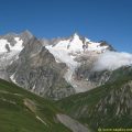
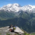
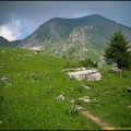
Photos of the Bivouac du Petit Mont Blanc


Route
Download the route (KML) Download the route (GPX)
This post is also available in Français
About the Author
Pierre-Alexandre 33 ans, fondateur et webmaster de Randos-MontBlanc. Suivez-moi sur @pierrealexphotography


