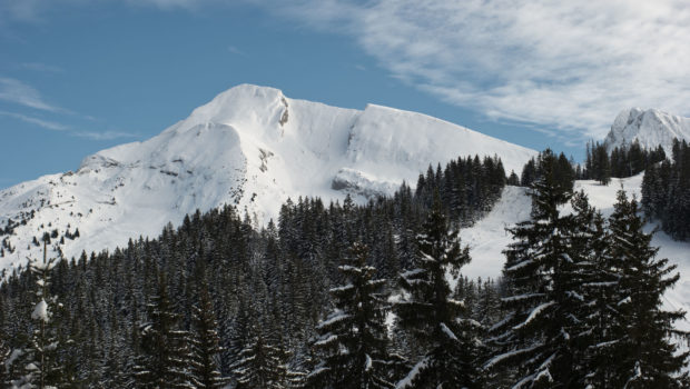
Pointe de Beauregard
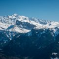
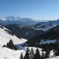
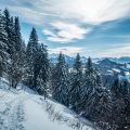
Offering beautiful views of the Aravis and Bargy Massif, Plateau and Pointe de Beauregard remain the site of a pretty winter snowshoeing trip. Easy, with a elevation gain of about 270 m, the route is accessible to everyone and allows one to reach Pointe de Beauregard, whose toponym is said to come from the word “belvedere”1. The trail starts at Col de la Croix Fry on the heights of La Clusaz. The path first runs through the forest before reaching the Plateau de Beauregard, where there is also the cross-country skiing area. It is also possible to do the itinerary through the “Fêtes de Colomban”, but it is more difficult, longer and, consequently, intended for good walkers.
- Difficulty: Easy
- Altitude: 1,644 m
- Ascent: 1 hour 30 min
- Descent: 1 hour 00 min
- Elevation Gain: 270 meters
- Round-trip: 6.2 km
- Map: IGN 3430 ET
Getting There
In the centre of La Clusaz, turn right at the roundabout to follow the direction of the Col de la Croix Fry. Once at the pass, park on the pass car park located on the right side of the road.
GPS Coordinates (WGS 84) of the Starting Point : 45.877337, 6.402553
Ascent
The trail departure is located to the right of the parking lot near a chalet. Follow the “Trail 10” signposting. The path then enters a fir forest by a short ascent offering beautiful views of the Etale Massif and the Mont-Blanc range. Further on, ignore the “Frête de Colomban (8)” trail located on the left and continue into the forest. The path then goes down a little bit and leads to a vast plateau dominated by Pointe de Beauregard. At the chalet at the bottom of the descent, take the path that turns to the left. The ascent is a little steeper until you reach two small chalets; from there, turn right to join the large chalet of Vaunessins, which has a remarkable facade “à l’ancienne”. Then continue the trail to Pointe de Beauregard.
Descent
Take the signposted path going to “Croix Fry” which completes the circuit and allows you to join the route of the outward journey to reach the car park.
Photos of Pointe de Beauregard
")
")
")
")
")
")
")
")
")
")
")
")
")
")
")
")
")
")
")
")
")
")
")
")
")
")
")
")
")
")
")
")
")
")
")
")
")
")
")
")
")
")
")
")
")
")
")
")
Route
Download the route (KML) Download the route (GPX)
- Buord, Jean-Philippe. Origine des noms des montagnes de la Haute-Savoie. Annecy: Color Verba Edition, 2015, p.48 ↵
This post is also available in Français
About the Author
Pierre-Alexandre 30 ans, fondateur et webmaster de Randos-MontBlanc. Suivez-moi sur @pierrealexphotography