Tête Pelouse
Tête Pelouse is the object of a superb hike that will make you discover the Aravis Range and the beautiful Valley of Confins. Not so far from the Lac and Pointe de Tardevant, the itinerary reaches a rocky summit not very frequented that offers an unforgettable point of view.
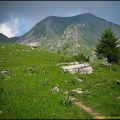
The path goes through the alpine pastures of the combe of Bella Cha. The descent, more physical but also more interesting in my opinion, passes through the combe du Grand Crêt.
The hike is classified difficult because of the elevation gain, the length, and the total absence of signage. The last 100 meters (optional) of the ascent of the Tête Pelouse require some vigilance at the descent as the ground is rocky and easily hidden under the feet.
There’s a little-exposed passage just before descending in the combe of Grand Crêt, which can impress people who have a fear of heights.
- Difficulty: Hard
- Altitude: 2,537 m
- Ascent: 3 hours 00 min to get to Tête Pelouse
- Descent: 2 hours 00 min
- Elevation Gain: 1,040 meters
- Round-trip: 8.4 km
- Map: IGN 3430 ET
Getting There
Get to La Clusaz. In the center of the village continue towards Les Confins. Park in the small parking lot on the right along the road about 200 m past the church, opposite the golf course.
GPS Coordinates (WGS 84) of the Starting Point: 45.922716, 6.483902
Ascent
From the car park, take the pathway that leads through the meadows facing the valley, and follow it along the small wood of pines on the left.
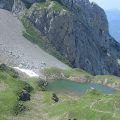
Very quickly, the footpath rises above the Lac des Confins by a succession of steep switchbacks.
After passing along the bottom of the cliff, the track goes more to the middle of the valley and gets to a long grassy ridge that you have to climb to reach a little plateau.
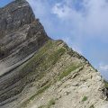
The cairn path now goes more to the left and reaches the bottom of a small scree where there remains a névé that it is necessary to cross to win a little pass. The summit is on the right at the end of a steep ridge.
Be careful: if the ascent of this ridge is easy, the descent is quite different on this rocky and slippery ground.
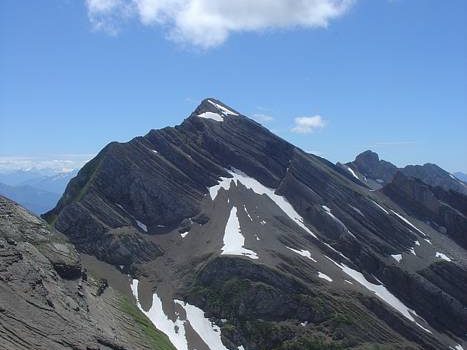
The panorama at the top of Tête Pelouse entirely erases the exertions; From the Bargy to the Mont Blanc Massif, the Aravis Range with the Pointe Percée visible above the Trou de la Mouche, and the impressive combe of Grand Crêt directly at your feet, the scenery is simply grandiose.
Descent
Go down carefully to the bottom of the ridge of the Tête Pelouse to find the passage that allows tilting on the other slope.
This one can impress at first sight, but the ground is safe, and once on it, the progression along the rocks is quite easy. A short, rather steep rocky passage and a scree reach a grassy flat. Go as far as you can to the center of the combe and continue down to the path leading to the Trou de la Mouche, opposite the Tête Pelouse.
All this part of the combe that you have just descended is not marked out. You should avoid staying leftmost: in fact, a very extensive scree complicates the progression unnecessarily.
Back on the pathway, the track is evident and the descent easier. The cliffs on the right are a popular place for climbing and it is not uncommon to see climbers hanging along the walls.
The trail reaches a road that leads to the car park of Les Confins.
Photos of Tête Pelouse


Route
Download the route (KML) Download the route (GPX)
This post is also available in Français
About the Author
Pierre-Alexandre 30 ans, fondateur et webmaster de Randos-MontBlanc. Suivez-moi sur @pierrealexphotography